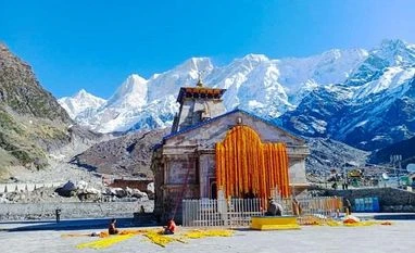
Rail Vikas Nigam Limited (RVNL), the implementing agency for the Rs 73,000 crore
Char Dham rail project, is against building a broad-gauge railway line on the proposed alignment to the holy shrine at Kedarnath.
After eight years of field surveys and studies, the RVNL has said in an internal assessment report that the Kedarnath link has “technical difficulties, exorbitant cost and does not serve any strategic purpose”. The broad-gauge line is critical to the project given the limitations of the terrain and the strategic needs of the Indian army.
ALSO READ - Collective effort needed to boost tourism, says Uttarakhand CM Dhami “The alignment being in a remote area with very little population and accessibility is not serving the local population. Therefore, in overall perspective, broad gauge rail network in 1:80 gradient for Kedarnath Dham is not recommended,” said the report submitted in April.
The Indian Railways did not respond to Business Standard’s queries seeking comments and clarifications.
Conceived in 2014, the Char Dham rail is one of the most ambitious and challenging railway projects in the world. It envisages construction of more than 300 km of railway lines through tunnels, over bridges, and on mountain slopes to connect the four holy Hindu shrines of Yamunotri, Gangotri, Kedarnath, and Badrinath – all in Uttarakhand.
Yamunotri and Gangotri were to be connected from Doiwala, near the state capital at Dehradun. Kedarnath and Badrinath, strategically important to the Indian army, were to be connected by extending the under-construction Rishikesh-Karnaprayag railway line.
In 2014, RVNL commissioned a reconnaissance survey that studied 30 different alignments for connecting all four shrines with a recommended alignment of 1:80. The suggestion was to extend the under-construction Rishikesh-Karnaprayag railway line to Saikot in the Garhwal district. From Saikot, two separate lines would branch out: one to Kedarnath and the other to Badrinath.
On the Kedarnath route, the railway line would culminate at Sonprayag, at a station that would be built at an altitude of 1,654 meters. Though Sonprayag is just 13 km from Kedarnath, the shrine is at an altitude of 3,553 meters – that means a steep climb.
The task of conducting a final location survey was given to a Turkish company in 2018, which submitted its final report recently after “detailed topographical, geological studies and refining the reconnaissance survey alignments.” It said that after Saikot, one line would divert towards Kedarnath and end at Sonprayag on a 91-km-long line. The Kedarnath shrine would be 18 km by foot from the Sonprayag railway station.
However, RVNL found that though the railway line could be extended till Saikot, building beyond that from Makkumath to the Sonprayag station was not feasible on the proposed alignment because of a “number of geological challenges due to seismically active main central thrust (MCT) zone and mostly underground stations characterized by large rock fragment constructability issues”.
The RVNL’s internal assessment report said the Kedarnath railway line offered no strategic advantages and, at 214 km, was longer than the road distance from Rishikesh to Sonprayag. It added that it would be more cost-effective to operate through the air route -- only 45 km -- between the two towns.
Unlock 30+ premium stories daily hand-picked by our editors, across devices on browser and app.
Pick your 5 favourite companies, get a daily email with all news updates on them.
Full access to our intuitive epaper - clip, save, share articles from any device; newspaper archives from 2006.
Preferential invites to Business Standard events.
Curated newsletters on markets, personal finance, policy & politics, start-ups, technology, and more.
)