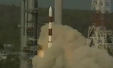
As scheduled at 16:00 hours the PSLV rocket standing 44.4 metres tall and weighing 320 tonne lifted off from the Sriharikota space port.
Read more from our special coverage on "ISRO"
With this success, India has now moved closer towards joining a select group of countries, which have their own satellite navigation system. The IRNSS will provide two types of services -- standard positioning service and restricted service. The former is provided to all users and the latter is an encrypted service for authorised users.
Indian Regional Navigation Satellite System (IRNSS) system consist of a constellation of seven satellites of which five were already put into orbit. On Thursday the sixth satellite was launched. Once all the seven satellites are in the orbit it will provide accurate position information service to users across the country and the region, extending up to an area of 1,500 kms.
The rocket, which launched today, was carrying 1,425 kg IRNSS-1F satellite.
In around 20 minutes into the flight, the PSLV rocket will eject its sole passenger IRNSS-1F at an altitude of 488.9 kms.
The satellite’s control will be taken over by the Mission Control Facility (MCF) at Hassan in Karnataka. It will manage the satellite’s orbit raising operations firing the on-board motors till it is placed in its slotted orbit.
According to Isro, the navigation payload of IRNSS-1F will transmit navigation service signals to the users. This payload will be operating in L5-band and S-band. A highly accurate rubidium atomic clock is part of the navigation payload of the satellite.
The ranging payload of IRNSS-1F consists of a C-band transponder (automatic receivers and transmitters of radio signals) which facilitates accurate determination of the range of the satellite.
IRNSS-1F also carries Corner Cube Retro Reflectors for laser ranging.
Till date, India has launched six regional navigational satellites (IRNSS-1A, 1B, 1C, ID, 1E and 1F) as part of a constellation of seven satellites. The last one is expected to be launched before the end of 2016.
Indian Space Research Organisation's sixth navigation satellite IRNSS-1F, on-board PSLV-C32 before its launch from the spaceport of Sriharikota in Andhra Pradesh
The full system comprises of nine satellites, including seven in orbit and two on the ground.Each satellite costs about Rs 150 crore and the PSLV-XL version rocket costs about Rs 130 crore. The seven rockets would entail an outlay of about Rs 910 crore.
The first satellite IRNSS-1A was launched in July 2013, the second IRNSS-1B in April 2014, the third on October 2014, the fourth in March 2015, and the fifth in January this year.
Once all the satellites are in place, India need not be dependent on other platforms.
Vice President, M Hamid Ansari congratulated ISRO, "I offer my congratulations to the Scientists, Engineers and Technicians of the Indian Space Research Organization (ISRO) for the successful launch of the of PSLV-C32 carrying IRNSS-1F satellite, the sixth in the seven satellite IRNSS constellation. The flawless launch has again demonstrated India’s capabilities in the space sector. I wish ISRO all the very best for the future."
The Prime Minister Narendra Modi also congratulated ISRO scientists on the successful launch of IRNSS1F into the orbit.
"Successful launch of IRNSS-1F is an accomplishment we all take immense pride in. I salute the hardwork of our scientists & ISRO," the Prime Minister said.
Sources said that IRNSS will also be used for defence purposes as well. The IRNSS is similar to the global positioning system (GPS) of the US (24 satellites), Glonass of Russia, and Galileo of Europe, China’s Beidou.
While GPS and Glonass are fully functional global systems, the Chinese and the Japanese systems are offering regional coverage and Europe’s Galileo is yet to be operational.
Experts also said IRNSS system consist only seven satellites while other systems in the world have more than 20 satellites.
)