The recent floods in Chennai are a stark reminder on the rampant real estate development in the city. Most of the lakes, ponds and other water storage areas have become either huge residential complexes or malls.
For example T Nagar, the city centre Chennai, used to have a huge tank. Today it has turned into one of India's largest retail hubs. Hundreds of shops were constructed illegally.
Similarly, the 400-kilometer long Buckingham Canal, built by the British for navigation, is another example of waterways that turned into drains. Experts says a failure to de-silt it and the lack of a plan for collecting rainwater is another reason for the floods, adding that it is high time to revive those drain spots.
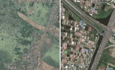
The maps in this article compare how many parts of the suburbans, around Chennai was in the past and now.
For example T Nagar, the city centre Chennai, used to have a huge tank. Today it has turned into one of India's largest retail hubs. Hundreds of shops were constructed illegally.
On left is a Google Earth image of Velachery area in 2000 and on right is the image in 2015 (Picture source: Activist Nityanand Jayaraman)
Similarly, the 400-kilometer long Buckingham Canal, built by the British for navigation, is another example of waterways that turned into drains. Experts says a failure to de-silt it and the lack of a plan for collecting rainwater is another reason for the floods, adding that it is high time to revive those drain spots.
The maps in this article compare how many parts of the suburbans, around Chennai was in the past and now.
This portion of the Pallikaranai marshland was encroached upon to accommodate a massive IT building (Picture source: Activist Nityanand Jayaraman)
)