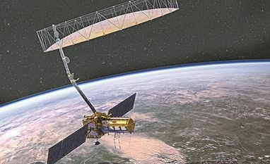
The Indian Space Research Organisation (Isro) has completed the development of a radar capable of producing extremely high-resolution images for a joint earth observation satellite mission with the National Aeronautics and Space Administration (Nasa).
The Nasa-Isro Synthetic Aperture Radar (NISAR) is a collaboration between the Indian and US space agencies for a dual-frequency L and S-band SAR for earth observation.
The S-Band SAR was shipped from the Space Applications Centre at Ahmedabad in Gujarat to the jet propulsion laboratory (JPL) at Pasadena in Los Angeles County, California, to be integrated with Nasa’s L-Bank SAR payload.
NISAR is estimated to be the world’s most expensive Earth imaging satellite. The total cost of the project includes Isro’s work share cost of about Rs 788 crore and about $808 million of JPL’s.
NISAR will be put into orbit in 2022 by Isro's Geosynchronous Satellite Launch Vehicle (GSLV) from the Satish Dhawan Space Centre at Sriharikota near Chennai.
Indian scientists have spent nearly three decades working to tame the cryogenic technology, which was denied to Isro by the United States in the early 1990s. India's completely indigenous technology was successfully tested in 2017 and it placed the country among the global space superpowers. It also led India to be one of the top hubs for launches. Isro now launches satellites for various countries, including the US. NISAR will add one more feather in Isro's cap.
The L&S band microwave data obtained from this satellite will be useful for a variety of application: To estimate agricultural biomass over the full duration of crop cycle; assessing soil moisture; monitoring of floods and oil slicks; coastal erosion; coastline changes; assessment of mangroves; surface deformation studies; ice sheet dynamics, among others.
Nasa said NISAR will be the first satellite mission to use two different radar frequencies (L-band and S-band) to measure changes in our planet's surface less than a centimeter across. The partnership with India has been key to preserving as much science as possible.
The radar penetrates clouds and darkness, enabling NISAR to collect data day and night in any weather.
In September 2014, Nasa and Isro had signed a partnership to collaborate on and launch NISAR for a dual-frequency L and S-Band SAR for earth observation. NISAR would provide a means of disentangling highly spatial and temporally complex processes, ranging from ecosystem disturbances to ice sheet collapses and natural hazards including earthquakes, tsunamis, volcanoes and landslides.
Nasa is providing the mission’s L-band synthetic aperture radar, a high-rate communication subsystem for science data, GPS receivers, a solid-state recorder and payload data subsystem. Isro is providing the spacecraft bus, the S-band radar, the launch vehicle and associated launch services.
Isro identified science and applications that were complementary to the primary mission objectives: Agricultural monitoring and characterisation, landslide studies, Himalayan glacier studies, soil moisture, coastal processes, coastal winds, and so on.
A second radar frequency was added to the mission to better fulfill these science requirements.
Since 1979, Isro has launched over 30 earth observation satellites. Both at central and state level, there are a large number of users who utilise space-based inputs for various purposes.
Eye on the border
Meanwhile, on March 28, the Geosynchronous Satellite Launch Vehicle (GSLV-F10) will fire Geo Imaging Satellite, GISAT-1, from Sriharikota. Operating from a geostationary orbit, the 2,268 kg GISAT-1 will facilitate near real-time observation of the Indian sub-continent, under cloud free condition, at frequent intervals. It will provide near real-time images of India’s borders and enable quick monitoring of natural disasters.
This will be the first agile Earth observation satellite to be placed in a Geosynchronous Transfer Orbit by GSLV-F10.
Unlock 30+ premium stories daily hand-picked by our editors, across devices on browser and app.
Pick your 5 favourite companies, get a daily email with all news updates on them.
Full access to our intuitive epaper - clip, save, share articles from any device; newspaper archives from 2006.
Preferential invites to Business Standard events.
Curated newsletters on markets, personal finance, policy & politics, start-ups, technology, and more.
)