
Cyclone Hudhud likely to make landfall in North Andhra
Southern Odisha will see less impact in terms of rains and wind speeds
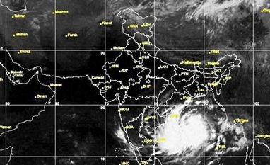)
Cyclone Hudhud
The severe cyclonic storm Hudhud is now expected to make a landfall point on north Andhra coast by early morning on Sunday, while causing less impact on Southern Odisha in terms of rains and wind speeds.
"The cyclone may make a landfall point around Visakhapatnam early morning tomorrow and there are chances that it may cross the seacoast even in Srikakulam," Andhra Pradesh government chief secretary I Y R Krishna Rao told Business Standard. He said that there was no threat of Hudhud becoming a super cyclone, though the administration is geared up to face any eventuality.
The cyclonic storm is being tracked by Visakhaptanam Doppler Weather Radar since Saturday morning, as it moved into its range.
According to an official weather bulletin issued today morning, the system moved west-north westwards across the Bay of Bengal for the past six hours. The cyclone is expected to move in a similar direction for some more time before moving north-westwards to cross North Andhra Pradesh coast around Visakhapatnam by Sunday forenoon.
The wind speed would gradually increase to 140-150 kmph gusting to 165 kmph around the time of landfall along and off north Andhra Pradesh (East Godavari, Visakhapatnam, Vizianagaram and Srikakulam districts) and 80-90 kmph around and off the adjoining districts of South Andhra Pradesh and South Odisha (Ganjam, Gajapati, Koraput and Malkangiri districts), according to the weather report.

Eastern and Southern Railways have cancelled many rail services and diverted some as severe cyclonic storms such as this could cause damage to the railway network in the vicinity of landfall point by flooding.
Under the influence of the system, extensive damage to communication lines, minor disruption of rail and road traffic, potential threat from flying debris, flooding of escape routes among other damages are likely to occur in areas of both North Andhra and West Odisha, according to the report .
Andhra Pradesh government stated that nearly 5.15 lakh people were likely to evacuated from 436 cyclone prone villages in 64 mandals of five out of a total of nine coastal districts in the state.
A total of 370 relief camps were being set up while 689 swimmers, 54 boats, 13 NDRF teams , two columns of Army personnel and 30 teams of the Indian Navy were positioned to undertake rescue and relief operations. All essential commodities were stocked and special officers were appointed to each of the cyclone prone mandals.
Even after landfall, according to IMD, the system would maintain the intensity of very severe cyclonic storm for six hours and gradually weaken into a cyclonic storm in subsequent six hours while moving northwestwards across south interior Odisha and Chattisgarh.
Don't miss the most important news and views of the day. Get them on our Telegram channel
First Published: Oct 11 2014 | 12:28 PM IST