Is the monsoon current emanating from the Bay of Bengal shifting its position towards central India, causing more rains over Madhya Pradesh, Chhattisgarh, Odisha, and Andhra Pradesh, and leaving less for Punjab, Haryana, and Delhi?
Yes, according to a section of meteorologists. Data from India Meteorological Department (IMD), too, partially supports this view.
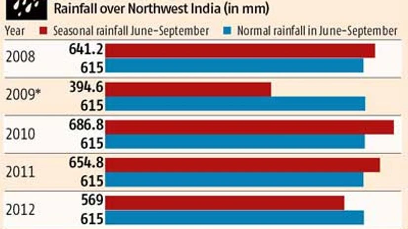
The data shows that total rainfall received in plains of North-West India - comprising Punjab, Haryana, Delhi, and Rajasthan - has fallen from 686.8 millimetres in 2010 to 654.8 millimetres in 2011 and 569 millimetres in 2012. Barring 2012, rains were normal at 615 millimetres in the region.
However, the fall has definitely raised some doubts in the minds of a section of meteorologists.
North-west India gets its rainfall both from monsoon currents emanating from Arabian Sea as well as from the Bay of Bengal.
"Yes, the amount of rainfall that North-West India is getting since the last two-three years is falling, but it is well within the normal range and absolutely no cause for worry," said D S Pai, director (long range forecast), IMD.
Mahesh Palawat, chief Meteorologist at Skymet Weather Services Ltd, a private weather forecaster, said the monsoon current emanating from the Bay of Bengal is showing definite signs of moving more towards the west or west -north-westerly direction, causing more rainfall over the Telangana region of Andhra Pradesh, North Andhra Pradesh, Madhya Pradesh, Chhattisgarh, rather than Punjab and Haryana.
Palawat said this shift, which may be because of climate change, is gradually pulling down the total rainfall over some parts of north-western India.
However, IMD's Pai said it is not yet proved that rains from Bay of Bengal are shifting more towards central India.
In 2013, too, IMD in its second stage forecast said that rainfall during the four-month southwest monsoon season over much of North-West India is likely to be below normal at 94 per cent of the long-period average.

"A trend of two-three years is too early to make any concrete judgment," said Ajit Tyagi, former director-general of IMD. He said the seasonal variation in rainfall needs to be followed for at least a decade, to establish any firm trend.
As of now, there is no cause for worry, said Tyagi. Plains of North-West India, comprising Punjab, Haryana, some regions of Uttar Pradesh, and Rajasthan contribute over 80 per cent of wheat and more than 60-70 per cent of rice produced in the country.
However, the most heartening factor is almost 80 per cent of total arable land in states such as Punjab and Haryana is under irrigation.

)
