Odisha aims for zero casualty as Hud Hud intensifies
Heavy rains and wind blasts to be experienced in cyclone zone from today
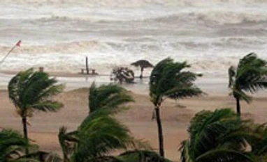)
Cyclonic storm Hud Hud formed in the Bay of Bengal today intensified into a very severe cyclonic storm and inched its way towards the east coast, the Odisha government has further beefed up its preparedness, aiming at zero casualty due to the storm.As per the latest reports, Hud Hud, which is expected to have a landfall near Visakhapatnam in Seemandhra on October 12 morning, now lies lies 520 kms south-southeast of Gopalpur.
While the wind speed in four north Seemandhra districts, East Godavari, Srikakulam, Visakhapatnam, and Vizianagaram, which will bear maximum brunt of the storm, may reach 155 kms per hour at the time of landfall, the same is expected at 80 to 90 kms in south Odisha districts.
The Odisha government has despatched rescue teams to regions vulnerable to the cyclone. "At least 25 teams, 15 of NDRF (National Disaster Response Force) and 10 ODRAF (Odisha Disaster Rapid Action Force) , have been deployed at vulnerable areas keeping an eye on the cyclone and heavy rainfall”, said Special Relief Commissioner Pradipta K Mohapatra.
The rescue teams have been deployed to 17 districts of the state likely to be impacted by the storm. The 10 ODRAF units have been sent to Koraput, Malkangiri, Nabarangpur, Rayagada, Khurda, Gajapati, Kandhamal, Puri, Cuttack and Jagatsinghpur. Four additional teams of NDRF are expected to reach the state today.
The cyclone is set to bring heavy rainfall in undivided Koraoput comprising Koraput, Malkangiri and Rayagada. Other southern Odisha districts likely to be hit are Kandhamal, Kalahandi, Nayagarh, Gajapti and Ganjam.
“All the districts have been provided with satellite phones for emergency and constant vigil is being maintained on rivers like Bansadhara, Rushikulya and Nagabali since cyclone induced heavy rains are expected in all southern districts”, said Mohapatra.
“We have instructed the collectors to ensure that people do not remain inside kutcha houses. All such people need to be evacuated to safer places”, he added.
Ganjam, Gajapati, Koraput and Malkangiri are set to bear most damage from the cyclonic storm. Wind speed in these regions is expected in the range of 80-90 km an hour, said Mritunjay Mohaptara, director of India Meteorological Department's (IMD) cyclone warning centre.
Latest bulletin issued by IMD says sea condition would become very rough from the morning of October 11 and gradually become phenomenal from October 12 morning onwards along and off Andhra and Odisha coasts.
Under the influence of the cyclonic system, extensive damage may be caused to kutcha houses besides uprooting of big trees, partial disruption of power and communication lines and minor disruption of rail and road traffic.
Keeping the situation in view, the state chief secretary G C Pati has called for adequate preparedness measures to effectively combat the disaster.
He has instructed the district collectors to immediately prepare and keep the evacuation plans ready for their respective districts ready, giving highest priority to the vulnerable villages and habitations.
“All cyclone and flood shelters should be immediately checked and made ready to house the evacuees. The water supply, lighting, and sanitation arrangements in the shelters should be checked and curative measures be taken if required”, Pati said in a letter to the district collectors and all administrative departments.
He has also called for immediate restoration of road communication for movement of relief materials to the affected areas. Since power supply is likely to be cut off during the peak period of cyclone, all offices need to have back-up power arrangements for that period, Pati said.
While the wind speed in four north Seemandhra districts, East Godavari, Srikakulam, Visakhapatnam, and Vizianagaram, which will bear maximum brunt of the storm, may reach 155 kms per hour at the time of landfall, the same is expected at 80 to 90 kms in south Odisha districts.
The Odisha government has despatched rescue teams to regions vulnerable to the cyclone. "At least 25 teams, 15 of NDRF (National Disaster Response Force) and 10 ODRAF (Odisha Disaster Rapid Action Force) , have been deployed at vulnerable areas keeping an eye on the cyclone and heavy rainfall”, said Special Relief Commissioner Pradipta K Mohapatra.

The rescue teams have been deployed to 17 districts of the state likely to be impacted by the storm. The 10 ODRAF units have been sent to Koraput, Malkangiri, Nabarangpur, Rayagada, Khurda, Gajapati, Kandhamal, Puri, Cuttack and Jagatsinghpur. Four additional teams of NDRF are expected to reach the state today.
The cyclone is set to bring heavy rainfall in undivided Koraoput comprising Koraput, Malkangiri and Rayagada. Other southern Odisha districts likely to be hit are Kandhamal, Kalahandi, Nayagarh, Gajapti and Ganjam.
“All the districts have been provided with satellite phones for emergency and constant vigil is being maintained on rivers like Bansadhara, Rushikulya and Nagabali since cyclone induced heavy rains are expected in all southern districts”, said Mohapatra.
“We have instructed the collectors to ensure that people do not remain inside kutcha houses. All such people need to be evacuated to safer places”, he added.
Ganjam, Gajapati, Koraput and Malkangiri are set to bear most damage from the cyclonic storm. Wind speed in these regions is expected in the range of 80-90 km an hour, said Mritunjay Mohaptara, director of India Meteorological Department's (IMD) cyclone warning centre.
Latest bulletin issued by IMD says sea condition would become very rough from the morning of October 11 and gradually become phenomenal from October 12 morning onwards along and off Andhra and Odisha coasts.
Under the influence of the cyclonic system, extensive damage may be caused to kutcha houses besides uprooting of big trees, partial disruption of power and communication lines and minor disruption of rail and road traffic.
Keeping the situation in view, the state chief secretary G C Pati has called for adequate preparedness measures to effectively combat the disaster.
He has instructed the district collectors to immediately prepare and keep the evacuation plans ready for their respective districts ready, giving highest priority to the vulnerable villages and habitations.
“All cyclone and flood shelters should be immediately checked and made ready to house the evacuees. The water supply, lighting, and sanitation arrangements in the shelters should be checked and curative measures be taken if required”, Pati said in a letter to the district collectors and all administrative departments.
He has also called for immediate restoration of road communication for movement of relief materials to the affected areas. Since power supply is likely to be cut off during the peak period of cyclone, all offices need to have back-up power arrangements for that period, Pati said.
Don't miss the most important news and views of the day. Get them on our Telegram channel
First Published: Oct 10 2014 | 8:20 PM IST