Hurricane Ian strikes Cuba, Florida braces for Category 4 damages
Ian sustained top winds of 205 kmph as it moved over the city of Pinar del Rio. As much as 14 feet of storm surge was predicted along Cuba's coast
)
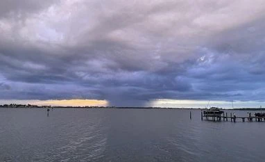
Hurricane Ian arriving at Tampa Bay (Photo: Twitter)
Hurricane Ian tore into western Cuba on Tuesday as a major hurricane, with nothing to stop it from intensifying into a catastrophic Category 4 hurricane before it hits Florida on Wednesday.
Ian made landfall at 4:30 a.m. EDT Tuesday in Cuba's Pinar del Rio province, where officials set up 55 shelters, evacuated 50,000 people, rushed in emergency personnel and took steps to protect crops in Cuba's main tobacco-growing region.
The U.S. National Hurricane Centre said significant wind and storm surge impacts were occurring Tuesday morning in western Cuba.
Ian sustained top winds of 205 kmph as it moved over the city of Pinar del Rio. As much as 14 feet of storm surge was predicted along Cuba's coast.
After passing over Cuba, Ian was forecast to strengthen even more over warm Gulf of Mexico waters, reaching top winds of 225 kmh before making landfall again.
Also Read
Tropical storm-force winds were expected in Florida late Tuesday, reaching hurricane force Wednesday morning.
The hurricane centre said there's a 100 percent chance of damaging winds and water along Florida's west coast, issuing a hurricane warning from Bonita Beach north through Tampa Bay to the Anclote River.
Tampa and St. Petersburg could get their first direct hit by a major hurricane since 1921.
Please treat this storm seriously. It's the real deal. This is not a drill, Hillsborough County Emergency Management Director Timothy Dudley said Monday at a news conference on storm preparations in Tampa.
Western Cuba is relatively lightly populated, but with tropical storm force winds extending outward 185 kilometers from Ian's centre, Cuba's capital wasn't spared.
Havana's residents openly worried about flooding ahead of the storm, with workers unclogging storm drains and fishermen taking their boats out of the water.
I am very scared because my house gets completely flooded, with water up to here, Adyz Ladron said, pointing to his chest.
In Havana's El Fanguito, a poor neighbourhood near the Almendares River, residents packed up what they could.
I hope we escape this one because it would be the end of us. We already have so little, health worker Abel Rodrigues said.
Ian's forward movement was expected to slow over the gulf, enabling the hurricane to grow wider and stronger before it brings punishing wind and water to Florida's west coast. Forecasters said the surge of ocean water could reach 3 metres if it peaks at high tide.
Rainfall could total 41 centimetres and 61 centimeters in isolated areas.
Coastal communities could be inundated.
As many as 300,000 people may be evacuated from low-lying areas in Hillsborough County alone, county administrator Bonnie Wise said. Some of those evacuations were beginning Monday afternoon in the most vulnerable areas, with schools and other locations opening as shelters.
We must do everything we can to protect our residents. Time is of the essence, Wise said.
Floridians lined up for hours in Tampa to collect bags of sand and cleared store shelves of bottled water. Gov. Ron DeSantis declared a statewide emergency and warned that Ian could lash large areas of the state, knocking out power and interrupting fuel supplies.
You have a significant storm that may end up being a Category 4 hurricane," DeSantis said at a news conference Monday. "That's going to cause a huge amount of storm surge. You're going to have flood events. You're going to have a lot of different impacts.
DeSantis said the state has suspended tolls around the Tampa Bay area and mobilised 5,000 Florida state national guard troops, with another 2,000 on standby in neighbouring states.
President Joe Biden also declared an emergency, authorising the Department of Homeland Security and the Federal Emergency Management Agency to coordinate disaster relief and provide assistance to protect lives and property. The president postponed a scheduled Tuesday trip to Florida because of the storm.
Playing it safe, NASA was rolling its moon rocket from the launch pad to its Kennedy Space Centre hangar, adding weeks of delay to the test flight.
The Tampa Bay Buccaneers announced it was relocating football operations to the Miami area on Tuesday in preparation for next weekend's game against the Kansas City Chiefs.
Damaging winds and flooding was expected across the entire peninsula as Ian moves north, reaching into Georgia, South Carolina and other parts of the southeastern United States on Friday and Sunday, the hurricane centre said.
(Only the headline and picture of this report may have been reworked by the Business Standard staff; the rest of the content is auto-generated from a syndicated feed.)
More From This Section
Don't miss the most important news and views of the day. Get them on our Telegram channel
First Published: Sep 27 2022 | 7:14 PM IST

